To get the large boat through a shallow spot in the Long Reach of the Ohio, the crew must cut a channel through the gravel. They anchor about nine miles upstream from Marietta, Ohio.
On his way to the Mississippi Territory, Thomas Rodney writes a letter to President Thomas Jefferson with news of Lewis’s trip down the Ohio.
Long Reach of the Ohio
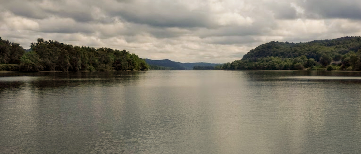
By Carol Greathouse, July 2018.
Long Reach of the Ohio (1814)
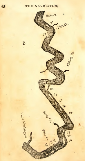
Zadok Cramer, The Navigator (1814).
This map, from the 1814 edition of Zadok Cramer’s Navigator was not included in the edition that Lewis took with him in 1803. Without maps, the earlier pilots often had difficulty identifying Cramer’s landmarks. This is certainly true of Thomas Rodney who traveled at the same time as Lewis and also used an earlier edition of the Navigator. This type of confusion may be the reason that Lewis’s descriptions of the morning’s camp and Wilson’s Riffle appear contradictory.[1]See Moulton, Journals, 1:80n1. This map labels the following landmarks:
23: Peyton’s Island
24: Williamson’s Island
25: Pursley’s Island
26: Wilson’s Island
27: John Williamson’s Island
28: Little Island
29: Bat Island
30: Middle Island
31–33: Three Brothers Islands[2]Zadok Cramer, The Navigator: Containing Directions for Navigating the Monongahela, Allegheny, Ohio and Mississippi Rivers… (Pittsburgh: Cramer, Spear and Eichbaum, 1814), 37–41.
Cutting a Channel
set out at sunrise it began to rain and continued with some intervals untill three in the evening passed several bad riffles and one particularly at the lower end of the long reach called Willson’s riffle here we were obliged to cut a channel through the gravel with our spade and canoe paddles and then drag the boat through
—Meriwether Lewis
Ohio River Gravel Bars
On board my boat opposite Marietta.
September 13th. 1803.Dear Sir [Thomas Jefferson],
I was obliged to cut a passage through four or five bars, and by that means past them: this last operation is much more readily performed than you would imagin; the gravel of which many of these bars are formed, being small and lying in a loose state is readily removed with a spade, or even with a wooden shovel and when set in motion the current drives it a considerable distance before it subsides or again settles at the bottom; in this manner I have cut a passage for my boat of 50 yards in length in the course of an hour; this method however is impracticable when driftwood or clay in any quantity is intermixed with the gravel; in such cases Horses or oxen are the last resort: I find them the most efficient sailors in the present state of the navigation of this river, altho’ they may be considered somewhat clumsey.—
I have the honour to be with much respect Your Obt. Servt.
Meriwether Lewis.
Capt. 1st. US. Regt. Infty.[3]Founders Online, National Archives, founders.archives.gov/documents/Jefferson/01-41-02-0280. [Original source: The Papers of Thomas Jefferson, vol. 41, 11 July–15 November 1803, ed. Barbara B. … Continue reading
Rodney’s Update
Wheeling Monday Septr. 12th. 1803.
Dr Sir
. . . . .
It is Said by those who reside here that they Never saw less water in the Ohio—many Riffs or shoals have not more than 15 or 18 Inches water over them, but as our Batteau will not draw more than 8 or 10 Inches water none of them will Stop us.
Captn. Lewis left here on Fryday last—he had some trouble in Coming from Pittsburg down here by having to unload and to have his Barge drawn by Oxen over several riffs or Shoals—before he left here he made his boat as light as possible by putting his lading in several Canoes—we heard of him after he had passed 16 miles below this, when he had passed Several of the worst riffs or Shoals below this place without their stoping him and probably he will Soon reach better waters—yet as Our Boat is much Lighter than his we Expect to Overtake him before he gits out of the Ohio. With Sentiments of the highest respect and Esteem I remain
Your Most Obedient
Thomas Rodney
Experience the Lewis and Clark Trail
The Lewis and Clark Trail Experience—our sister site at lewisandclark.travel—connects the world to people and places on the Lewis and Clark Trail.
Plan a trip related to September 12, 1803:
Notes
| ↑1 | See Moulton, Journals, 1:80n1. |
|---|---|
| ↑2 | Zadok Cramer, The Navigator: Containing Directions for Navigating the Monongahela, Allegheny, Ohio and Mississippi Rivers… (Pittsburgh: Cramer, Spear and Eichbaum, 1814), 37–41. |
| ↑3 | Founders Online, National Archives, founders.archives.gov/documents/Jefferson/01-41-02-0280. [Original source: The Papers of Thomas Jefferson, vol. 41, 11 July–15 November 1803, ed. Barbara B. Oberg. Princeton: Princeton University Press, 2014, pp. 380–381.]; also in Letters of the Lewis and Clark Expedition with Related Documents: 1783-1854, 2nd ed., (Urbana: University of Illinois Press, 1978), 124. |