After yesterday’s successful passage through Letart Falls, Lewis commandeers the boats down the Ohio, likely reaching the settlements of Point Pleasant and Gallipolis.[1]Because we have no journal entry from Lewis for this day, his exact location is unknown. He was at Letart Falls on 18 September and arrived in Cincinnati on 28 September. Based on Thomas … Continue reading Coming down the Ohio a week later, Col. Thomas Rodney sees about ten log houses at the mouth of the Kanawha and at the French settlement of Gallipolis, a long island presents a significant hazard.
Battle Monument at Tu-Endie-Wei State Park
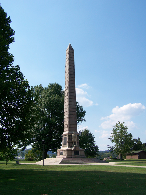
© 2007 by Brian M. Powell. Permission via the Creative Commons Attribution-Share Alike 3.0 Unported license.
Point Pleasant
The town of Mount Pleasant contains only 8 or 10 houses logged and framed and look but mean for such a place. Here Du[n]more was in 1774, and here General Lewes had a battle with the Indians. Many bones still remain but slightly burried and here was once a large town of the Indians extending, Pryor says, 3 miles up the Ohio from the Cawhawah. There is still great evidence of this.
—Thomas Rodney (28 September 1803)[2]Dwight L. Smith and Ray Swick, ed., A Journey Through the West: Thomas Rodney’s 1803 Journal from Delaware to the Mississippi Territory (Athens: Ohio University Press, 1997), 82. Lewis … Continue reading
Camp Point Pleasant at the mouth of the Kanawha River was established by Colonel Andrew Lewis (1720–1781) after his Battle of Point Pleasant victory in 1774. Part of Lord Dunmore’s war, the battle pitted roughly equal forces of Virginia militiamen against Shawnee and Mingo warriors. The site continued as a military establishment of various types for many years. Today, monuments, markers, and a reconstructed fort can be visited at Tu-Endie-Wei State Parks shown in the figure.[3]Point Pleasant, West Virginia, en.wikipedia.org/wiki/Point_Pleasant,_West_Virginia, accessed on 30 December 2018.
What Lewis thought of Point Pleasant, we do not know as today, a gap appears in his Ohio River journal. We do know that the memory of Lord Dunmore’s War was ever-present in the minds of the Virginia militia in 1994 when Lewis served as a member during the Whiskey Rebellion. For more, see Prior Military Careers.
High Water Line
There is a large cillender faced single rock a little way below it on the same side of the river. I observed by leaves hung on the bushes near that the Ohio some times swells to the top of this rock, which must be at present 25 or 30 ft. above the water . . . .
—Thomas Rodney (27 September 1803)[4]Smith and Swick, 78.
Sickly Gallipolis
A Map: A Tract of Land granted by the Congress to The French Inhabitants of Gallipolis. Part of Kentucky
Survey by Absalom Martin [c. 1800]
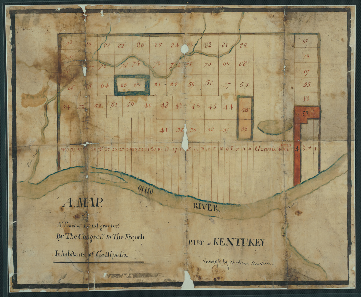
Courtesy of the Ohio History Connection, VFM0260-2.
About a mile or more down below Canhawah we reached the uper end of Galliopolis Island a pretty large island a mile and a half or two miles long. There is a riffle at the uper and lower end of this island and a rapid from one to the other. [Back of the town a little way the country appeared sunken and low and the place is said to be sickly.
—Thomas Rodney (28 September 1803)[5]Ibid., 82–83.
From Rodney’s journal, we learn that Lewis’s crews would have struggled to get the barge past the riffles and rapids around the long island opposite Gallipolis. He likely had the boats stop for the day above or below this island—now inundated.
The long, narrow lots shown above were common in settlements founded by Canadiens, called simply the “French” by Americans in 1803. The narrow shape allowed families to have access to the main transportation route, the river, and still have enough land to manage their home. Other examples of early cities with narrow lots include Detroit and Green Bay.[6]Robert Foxcurran, Michel Bouchard, and Sébastien Malette, Songs Upon the Rivers: The Buried History of the French-Speaking Canadiens and Métis . . . (Quebec: Baraka Books, 2016), 303.
Experience the Lewis and Clark Trail
The Lewis and Clark Trail Experience—our sister site at lewisandclark.travel—connects the world to people and places on the Lewis and Clark Trail.
Plan a trip related to September 19, 1803:
Notes
| ↑1 | Because we have no journal entry from Lewis for this day, his exact location is unknown. He was at Letart Falls on 18 September and arrived in Cincinnati on 28 September. Based on Thomas Rodney’s journal of his similar trip down the Ohio and Cramer’s 1802 river guide, The Navigator, it is a conjecture that Lewis stopped or passed by Point Pleasant and Gallipolis on this day. |
|---|---|
| ↑2 | Dwight L. Smith and Ray Swick, ed., A Journey Through the West: Thomas Rodney’s 1803 Journal from Delaware to the Mississippi Territory (Athens: Ohio University Press, 1997), 82. Lewis (Rodney’s Lewes) and Pryor are not Meriwether Lewis or Nathaniel Pryor of the Lewis and Clark Expedition. |
| ↑3 | Point Pleasant, West Virginia, en.wikipedia.org/wiki/Point_Pleasant,_West_Virginia, accessed on 30 December 2018. |
| ↑4 | Smith and Swick, 78. |
| ↑5 | Ibid., 82–83. |
| ↑6 | Robert Foxcurran, Michel Bouchard, and Sébastien Malette, Songs Upon the Rivers: The Buried History of the French-Speaking Canadiens and Métis . . . (Quebec: Baraka Books, 2016), 303. |